Hazard DB

Stay ahead of the curve with our browser-based interface, providing instant access to essential maps and data covering climate change, catastrophic event impact, population density, and more.


Sign Up Today

Comprehensive Hazard Risk Data for the USA

With HazardDB Risk Assessments, you gain access to a wealth of crucial information tailored to any property in the USA. Our Riskmap feature provides a visual representation of risk ratings, allowing you to quickly assess the level of risk associated with a property. From natural hazards to manmade risks, HazardDB covers it all.

65,800 +20%

WildfiresNational Avg

1,204 +5%

Earthquakes National Avg

2,690 +12,5

HurricanesNational Avg

2,690 +12,5

FloodsNational Avg

Understand Your Hazard Risk

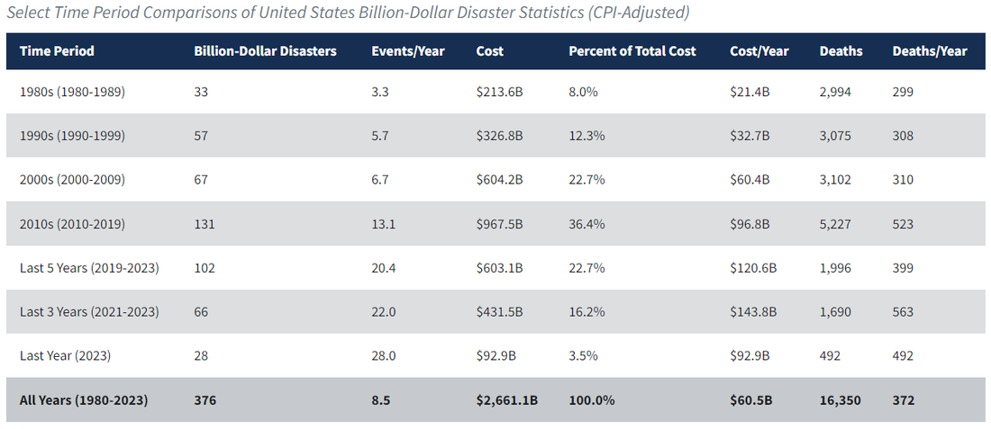
The number of large-loss natural hazard events reached record levels in 2023, with 66 billion-dollar economic loss events, and 37 billion-dollar insured loss events.


Mitigate Disaster Related Expenses

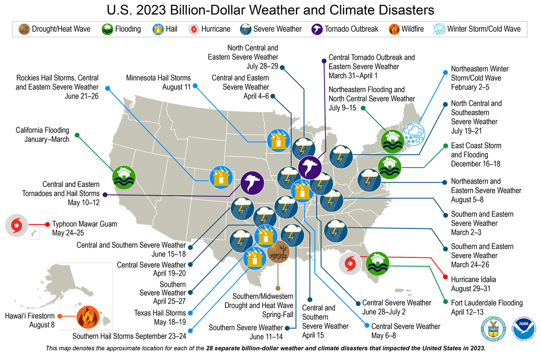
There were 28 weather and climate disasters in 2023, surpassing the previous record of 22 in 2020. The year 2023 was the warmest year since global records began in 1850 at 1.18°C (2.12°F) above the 20th century average of 13.9°C (57.0°F). The 10 warmest years in the 174-year record have all occurred during the last decade (2014–2023)


Risk Assessments for Anywhere in the USA

Property Search

Search for residential and commercial properties across the USA, along with any region down to the tract level.

Hazard Scores

Access our proprietary HazardDB Risk Scores across a multitude of natural catastrophes from floods and wildfires, to hurricanes and earthquakes.

Event Timelines

Go back in time with historical event timelines, and explore the underlying details for each event.

3D Mapping

Roam the 3D map and search for historical events, make measurements, research climate factors, view hazard zones, and much more.


Trusted by Industry Leaders


HazardDB has been a game-changer for Snoflo, empowering us to deliver unparalleled insights and solutions to our users.

SNOFLO

Climate Research Team

By seamlessly integrating natural catastrophe data with climate data, HazardDB has enabled Snoflo to enhance their understanding of potential risks and develop more informed solutions. Our comprehensive database and seamless integration capabilities have streamlined operations and empowered organizations to stay ahead in a rapidly evolving landscape.

HazardDB's reliable data and exceptional support exceeded expectations. Our insights have informed Snoflo decision-making processes and enabled them to develop robust risk mitigation strategies. But it's not just about identifying risks; it's also about knowing where safety resources are located. HazardDB Risk Assessments provide data on the nearest fire hydrants, fire stations, hospitals, and police stations, enabling you to factor in proximity to safety resources when evaluating property risk.

Gain a comprehensive understanding of the area climate with our Climate Overview feature, which includes average temperature, humidity, precipitation, and vegetation hardiness. This information is invaluable for assessing the susceptibility of a property to weather-related risks. Delve into the social demographics of the area with insights into the nearest schools. Understand the educational landscape surrounding the property, including the number and proximity of schools, providing valuable context for risk assessment. Finally, our Disaster Timeline feature gives you a historical perspective on disaster events in the area. Understand the frequency and severity of past disasters to better anticipate and prepare for future risks.

Powered by the Worlds Best

DOT
DOE
USACE
DOC
DOI
USGS
NASA
USDA
HUD
NOAA
DHS
EPA